
Civil Bytes: With 3D Scanning, There’s No Place to Hide
From uncovering history to protecting the president, applications abound for laser technology, and Mid-Pacific students in Honolulu are catching the wave.
Months before President Obama dips into his armored limo and princess-waves his way to a public podium, guess what the Secret Service is up to? Guess how they prep for the president’s public entrance and exit, his televised hand-waftings and burger-eatings, his intimate spa days where he laughs jovially with his completely non-existent political allies?
Here’s a hint: it requires hours of nerdy not hugging anyone. Another hint: one day, I hope to do this to my face.
The answer? The Secret Service props lidar scanners on tripods, and they shoot lasers into every nook and cranny of the soon-to-be public venue. Those lasers shoot back millions of data points of reflected light. Those data points are then stitched together, mapped to images, and converted into a granular three-dimensional digital model of the space.
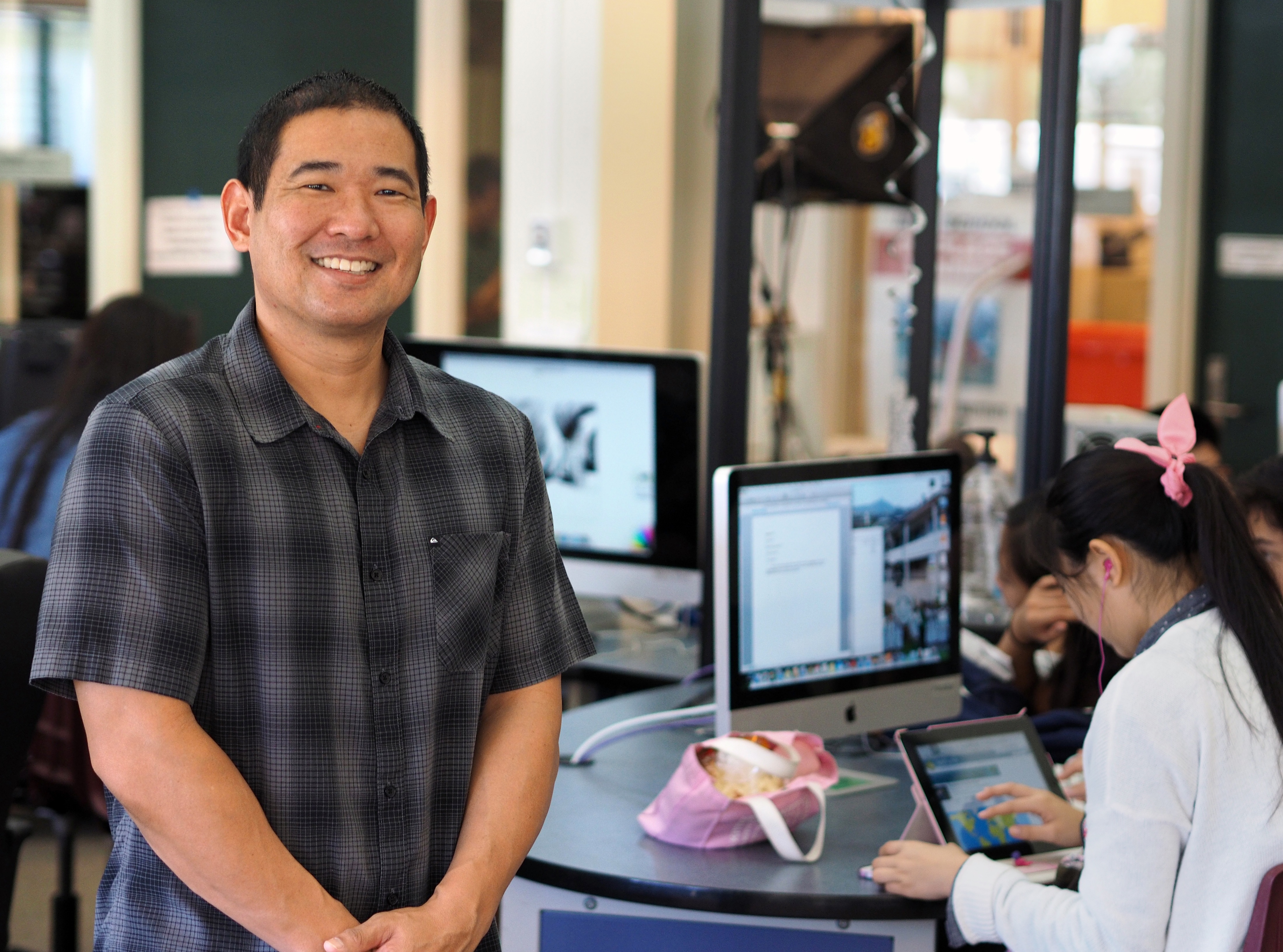
Brian Dote, chief information officer at Mid-Pacific Institute, has students working on 3D scanning projects.
Courtesy of Mid-Pacific Institute
It’s hundreds of hours of grueling work. Lots of screen time, sitting, glaring, dragging pixels, applying for private sector jobs. The analysts build and refine the model. Then they scrutinize it. They assess the potential grassy knolls, the blind spots and divots, the best rooftop to position Bradley Cooper atop, the bench where a Secret Service agent in a beige trench coat will sit and pretend to read a 40-year-old Washington Post. You get the idea.
I know what some of you are thinking. This whole 3D scanning and printing craze is really just a pastime for loveless engineers who invest oodles of hours designing and printing plastic parts that they could just as easily buy for pennies on Amazon. I’d agree with you, but I recently designed and printed earplugs that perfectly cap my ear canals and therefore make it delightfully impossible to hear you.
And, besides, 3D scanning is already being used to protect the president. What more do you want? It’s also at the heart of Google’s driverless car. And as if that’s not enough, in 2013, the 1,200-year-old ruins of Mahendraparvata, a city long forgotten in the green thicket of the Cambodian jungle, was rediscovered thanks only to a topographical map created using lidar.
The Invisible Visible
Dr. Aaron Morris, a researcher and roboticist at Autodesk, explains that the unique ability of 3D lidar scanning is its knack to make the “invisible visible.”
We can capture crime scenes in unbelievable detail. We can review the layout of underground pipes before accidentally severing a line during construction. We can investigate the destruction of a building at a hazardous site like Chernobyl or Fukushima Daiichi before blindly sending in a cleanup crew.
But, in my opinion, more interesting than any of this — more interesting than lidar’s ability to make the invisible visible — is its ability to preserve the invisible once captured. Lidar can document and archive artifacts for future generations in a way that makes standard photography fall flat.
We can, in effect, archive our world for folks more advanced and tolerant and more covered in Teflon than we are. To ensure that, no matter what happens to us in the end, tsunami or asteroid or roiling war, our artifacts and our stories outlive us. If we can’t save our world, we can at least save it to disk.
‘Star Wars,’ a Student Film
“It would be like George Lucas showing up and teaching us how to make a film.”
That’s how Brian Dote, chief information officer of Mid-Pacific Institute, explains the unexpected turn of the day.
He was working with Tony Johansen, School Technology Specialist at Midpac, and a handful of students. They were visiting the Pacific Aviation Museum, setting up a 3D lidar scanner inside a Douglas SBD Dauntless dive bomber. Those dive bombers were once the scouting eyes and ears of the US Navy during World War II. They scanned for Japanese carriers in the vast Pacific. Now Dote and his students were scanning it.
A few miles away, at the USS Arizona memorial, some of the most talented engineers in the world were working in conjunction with the National Parks Service to construct a 3D model of the USS Arizona. It’s likely the most complicated 3D scan ever undertaken, requiring lidar, underwater photogrammetry, high-resolution sonar, and above-water laser scanning.
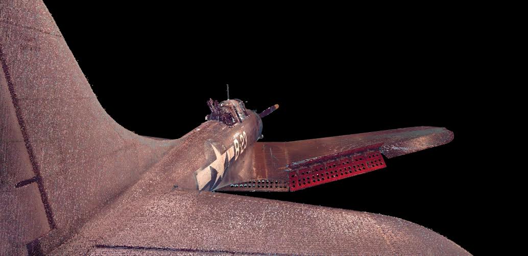
Midpac students spent hundreds of hours building a 3D image of a World War II bomber.
Courtesy of Mid-Pacific Institute
Imagine a dozen or so engineers in diving suits, lugging all kinds of clunky equipment around, recording billions of points in space with multiple technologies that rarely interface with one another. Then the team dries off, high-fives, and heads back to their offices to start stitching the pieces together.
When the team at the USS Arizona Memorial heard that a class of high school students were minutes away and that those students were working on a scan of their own, the engineers decided to visit and talk shop. As powerful and applicable as the technology is, after all, it’s rare for high school students to perform lidar scans. The equipment is expensive, the training is intensive, and the interest amongst Bieber fans is minimal. Hence, the engineers were excited to meet with what could become the next generation of digital preservationists, the scanners who will be tasked with scanning and preserving a much larger representation of our world.
“It was amazing,” Dote said. “They rolled up and started talking to our kids about scanning. Five minutes later, they’re bringing out their own scanners to help us. Ten minutes later, they’re giving a lecture to our students.”
That encounter stuck with Dote and the young scanners. More than ever, they understood the potential this technology embodied. They started scanning the world more fervently, with more purpose. Like Secret Service agents, they observed more acutely. They learned by preserving the ability for others to learn. And they leveraged the power of new technology to both digitally and emotionally process the Hawaii landscape.
Hidden History: The Honouliuli Gulch
In that spirit, Dote’s students are now working with the National Park Service to scan the 160-acre Honouliuli Internment Camp, where the U.S. interned hundreds of Japanese Americans during World War II.
The camp resides on Monsanto farmland and is barely recognizable. A few crumbled walls still stand here and there. History hides largely behind wild foliage.
Thanks in part to her work, the area was declared a National Historic site this week by President Obama.
After the war, the Oahu Sugar Company purchased the camp. The site was nearly forgotten about until 1990 when Jane Kurahara, a retired librarian and volunteer from the Japanese Cultural Center, went looking for it again.
Without the help of fancy topographical scanning, it took Kurahara over 12 years to finally find the site. As her starting point, she used an old faded photo of an aqueduct near the camp. She enlisted the help of a local farmer to locate the aqueduct and then she traced it back to the buried camp.
“It was history coming alive,” Kurahara said. “It all hit me. The things you read in books — the books hit your head. This hit your heart.”
Even as a librarian, Kurahara understood the personal impact of searching and investigating versus sitting and reading. Yes, reading has its place, of course. But there’s a connection in scanning and preserving that simply can’t be replicated on the pre-written page.
Thanks in part to her work, the area was declared a National Historic site this week by President Obama.
Agile in Education
Dote, a former Apple engineer and iOS developer, started his job as CIO of Midpac seven months ago. He’s the first CIO at the school, and he’s eagerly exposing students to cutting edge technologies like lidar.
It’s the trend. Every private school in Hawaii is pushing the envelope when it comes to tech.
“We don’t have the funds to build huge tech centers, but we’re small enough to be agile and try stuff out.” — Brian Dote, Mid-Pacific Institute
Sacred Hearts Academy, for example, requires that all students take a robotics class by the fifth grade. Punahou, with one of its students now a fully scan-protected president, offers an elective engineering course in sixth grade. Iolani totes the beautiful Sullivan Center, where students can learn video game design, film production, and iPad app development. And Midpac is one of the only K-12 schools in the country offering instruction in lidar scanning.
“In the world of education, you don’t see it anywhere else,” Dote said.
What Dote’s program offers that others may be lacking is a strong connection between place and the powers of tech.
“We don’t have the funds to build huge tech centers, but we’re small enough to be agile and try stuff out,” Dote said. “When we talk about engineering classes, most schools have programs. When we talk about programming and language classes, most schools have AP computer science classes. So it’s not those programs that set us apart. It’s the strength of what we’re doing on the cutting edge.”
Sure, building a popular iPad app may make a Zuckerbergian student millions of dollars, but it won’t necessarily connect him to history or people or place, or help him understand the true value of the inlet where he parks his yacht.
