

Curt Sanburn: Errant Towers or the Oahu That Never Was
Honolulu once allowed 40-story buildings just about anywhere on the island. Without changes, we might have also had highways on the reef and artificial island parks.
Those two tall and skinny gray towers, planted alone in the narrow ahupuaa of Manana, rising high above Pearl City’s suburban expanse. You know the ones.
Strange and astray like aliens when I first laid eyes on them in 1984. But, then again, they looked exactly like a building type popping up all over in Honolulu at the time. Maybe they were refugees. I worried these uglies were harbingers of some grim future for the rest of Oahu.
Two stacks of 43 floors, of stacked households, far from the city out on Kam Highway. But then I got used to them, and when they didn’t reproduce but remained singular and anomalous, they became just another Honolulu idiosyncrasy, like Salt Lake’s bleak landscape or that sidewalk-free tract in Moiliili — the permanent remains of one more sleazy, land-and-power episode in the ongoing construction of Oahu.
“What kind of planning is that?!” an outraged Gov. George Ariyoshi remarked to a reporter when the towers, called Century Park Plaza, suddenly sprouted in 1983.
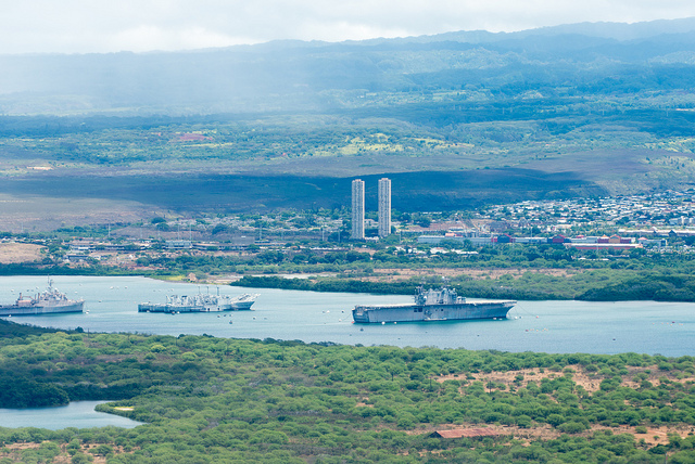
The 43-story Century Park Towers stand out in the suburban expanse of Pearl City.
D Coetzee via Flickr
As it turns out, in 1980 the City of Honolulu was itself eyeing the land where the towers now stand as a site to develop some federally funded affordable homes. This is according to veteran planner John P. Whalen, who was, back then, working for the city’s Department of Housing and Community Development, trying to get its poorly managed Community Development Block Grants program moving.
In an email, Whalen remembers the 35-year-old situation as follows:
“The city’s CDBG program was being monitored by HUD because of a poor drawdown rate and lack of focus on the needs of low- and moderate-income people, especially for affordable housing. The program we submitted to City Council that year included the purchase of the Manana site for a low-rise development consisting of mix of rentals in walk-up apartments and sales units in a townhouse configuration, all intended for eligible low- and moderate-income households.”
Just beyond Sandy Beach, Henry Kaiser envisioned a fake lagoon and beach at his resort district at Queen’s Beach. E. Alvey Wright wanted to build a freeway on the reef the length of Maunalua Bay.
He continues: “The budget request was mysteriously tied up in a City Council committee for several months, which I thought was strange, because the purchase of this site was such a great opportunity to both fulfill a clear community need and satisfy HUD monitoring requirements. I later found out that the developer of the twin towers, whose name I don’t remember, had come in to purchase about half of the site that we wanted and that certain City Council members were holding up our budget request until that purchase could be consummated.”
Century Park Plaza’s architect, Jo Paul Rognstad, now in his 80s, said he can’t remember the developer’s name, either, nor the date of the towers’ completion. But his assistant had earlier told me the developer’s name was Vernon Luke. After the project fell into bankruptcy, real estate kingpin Peter Savio purchased the towers from a Japanese investor and converted the rental project to condominiums.
In a phone interview, Rognstad told me he couldn’t find information about the Century Park Plaza project anywhere in his office — which is located in another tall, four-square tower he designed: the 40-story Century Center condominium, with its articulated floors of mirrored windows, at the intersection of Kapiolani and Kalakaua. The landmark building should not to be confused with the Century Square tower on Bishop Street, nor with the Executive Center, also on Bishop a block away, both of them also designed by Rognstad.
“I’ve got 25 buildings in Waikiki,” Rognstad, feisty and braggadocious, tells me, “and about seven of them are 40 stories.”
A few of them are veritable templates for Century Park Plaza: the Maile Sky Court hotel on Kuhio, the Hawaiian Monarch hotel on the Ala Wai, and the Windsor condominium at 343 Hobron Lane. (Another one is the Regency Tower condominium just across the canal on Date Street.)
For a change of pace, Rognstad also designed the Island Colony on the Ala Wai, with its bright blue, glazed-tile, Hawaiian roof/hat; and the gleaming white, modernist riff on his four-square template, the Waikiki Townhouse on Tusitala. His workhorse lanai-stacks include Academy Tower and Wilder Tower on Punchbowl, and the Makiki Manor and Makiki Royal in Makiki.
What was the mood in Honolulu when all those towers were going up in the late ’60s and ’70s, I ask Rognstad.
“At that point in time, there was tremendous demand for buildings, for condominiums, so my taller towers were popular, the public liked them. They sold well.”
Back then, the zoning allowed 350-foot buildings, or about 40 stories, “all over Oahu,” the architect remembers. “I could’ve built one of my towers in Mokuleia.”
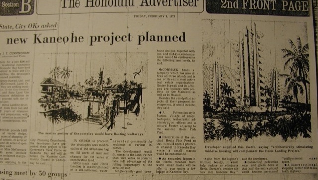
This article from a 1973 edition of The Honolulu Advertiser discusses the proposed development at rural Heeia, which subsequently became a protected wetland instead. It’s indicative of the prevalent development mindset in Honolulu at the time.
Curt Sanburn
Planner Whalen, now the unofficial czar of Kakaako as chairman of the state’s Hawaii Community Development Authority, concurs that the 1964 Oahu General Plan allowed 350-foot buildings almost everywhere, and points to places like Hawaii Kai, Kahala, Kailua, Kaneohe, and Kaimuki (the circular Kaimuki Jade!) that still have vestigial, seemingly errant towers that date from 1964 to 1984, when, finally, a significant amount of down-zoning occurred with the adoption of the island’s regional development plans.
He tells the story of a developer who put together some fast drawings for a 40-story condominium on the beach in Mokuleia in the mid-1970s, just before the city downzoned the area from 350 feet to 40 feet because the area had no sewers. The developer filed a takings lawsuit against the city. The suit was thrown out.
“Remember now,” Whalen says, “the ’64 General Plan was prepared right after statehood and the advent of jet travel, when there was a burst of enthusiasm for development.”
He tells me about how the General Plan, in addition to its 350-foot height allowances, designated tracts of land as well as reef for a deep-draft harbor, a power plant and a light industrial zone in Kahaluu.
He sighs. “Heeia was going to be filled in for a mix of single-family and apartments. Now it’s a protected wetland.”
The ’64 General Plan map shows artificial islands created just offshore to use as parks at Waimanalo, in Kaneohe bay and Keehi lagoon. Ala Moana’s fake island was targeted for hotels and maybe a convention center, Whalen tells me.
Just beyond Sandy Beach, Henry Kaiser envisioned a fake lagoon and beach at his resort district at Queen’s Beach. E. Alvey Wright wanted to build a freeway on the reef the length of Maunalua Bay! There were going to be limited-access boulevards everywhere, one of them running along the makai side of the Ala Wai Canal, where the roadway and promenade are now. Salt Lake, that’s another outgrowth of the ’64 General Plan.
“So, you see how important planning documents can be,” Whalen says.
For good and for ill, it seems to work both ways.

