Big Island: Noise From Helicopter Tours Leaves Residents With Frayed Nerves
It’s been a hot-button issue on the island for decades, but many say the problem has grown worse as more tourists are drawn to the site of the lava eruptions.
Steven Jacquier is known to many as “Aloha Steven.” But he’s run out of aloha for his daily visitors from the sky.
 Jacquier and his husband, Doran Vaughan, are preparing to move to Alaska because new steam vents spreading across their farm on Ala Ili Road in Lower Puna are threatening to make their home uninhabitable. But those same steam vents have made their neighborhood a tourist attraction for visitors who never pay.
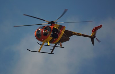
On May 7, Jacquier is sorting out which books to pack and which to donate to local schools, when an all-too-familiar whine begins to permeate the house. The whine changes into a deep throbbing roar. Jacquier rushes out into his back yard and waves his arms in an obscene gesture at its source: a tour helicopter, passing directly over their house.
Jacquier invited Civil Beat to his home to document the noise.
This turns out to be a relatively mild day: only 15 choppers pass over. Jacquier and Vaughan say that on many days, far more pass in sight (and sound) of their home. The noise has especially eaten on Jacquier’s nerves, already frayed from watching their farm die and preparing to leave the home they’d built.

Many of those helicopters appear to be passing much lower than the 1,500-foot altitude ceiling that they’re supposed to be observing, but that’s difficult to prove. The best the couple can do is estimate, based in part on a helicopter’s relation to nearby landmarks such as a 60-foot ham radio tower behind his house.
Drawn To The Volcano Action
The Ala Ili neighborhood is only the most recent on the Big Island to suffer this aural bombing.
The air tours tend to head by similar routes toward wherever the volcanic action is, which concentrates their impact often on already-traumatized lava victims. They say it threatens their physical and mental health.
Related
It’s been a problem for decades, but residents say it’s been getting worse, especially after recent lava events.
Leilani Estates resident Jean Graham says that during last year’s Lower Puna eruption, there was “never a free moment in the daytime from May to August. There were eight or 10 of them (tour helicopters) stacked up, flying in circles around Fissure 8. I’ve never experienced a community being ravaged by a disaster and these guys stacked up over them like flies over a body. They just didn’t care that people were dealing with this tragedy.”
Other hard-hit areas include Upper Ainaloa, on the flight path to Puu Oo, the epicenter of Kilauea’s volcanic activity for 30 years. The “red stuff” is gone for now, but Puu Oo still draws lots of flights.
Sharon Lee, 70, moved into a “sweet little place” in Ainaloa in 2013. Now she says she’s had enough. She’s moving to Hilo.
“I get about 40 or 50 a day now,” Lee says. “I should have left earlier. I was naive. I thought if I just could talk to those people, they would seek a reasonable solution.”
Companies Aided Residents During Lava Flows
There’s plenty of additional traffic around Hilo.
Aside from the Hawaiian Homelands neighborhoods next to the airport, there’s the flight path to Rainbow Falls. That’s where Don Carpenter, 74 and in poor health, has photographed hundreds of tour helicopters flying over his macadamia nut farm.
“I had 55 overflights low and slow over my house in one day,” he says. “Fifty or 60 overflights of tour helicopters is nuts. It’s a personal violation.
Last August, about 250 residents attended a meeting called by the Hawaii Department of Transportation to examine the issue. At the meeting, Mayor Harry Kim spoke on behalf of the residents.
“The anger is real. Their lifestyle is being infringed upon,” Kim said. “They know it’s getting worse, and we ask of you, please help them out.”

In an interview after the meeting, Paradise Helicopter Tours CEO Calvin Dorn acknowledged the frustration expressed by community members.
But he noted that during the lava emergency, the tour companies’ pilots and choppers had also flown residents out to their lava-isolated homes to retrieve personal belongings and mounted operations to rescue trapped animals.
“All these things take money, time and a helicopter, none of which we would have if we didn’t run some tours and support that business,” Dorn said.
Dorn did not respond to a request for a follow-up comment for this article.
Smiley Burrows calls Dorn “an awesome guy.”
Dorn’s company gave her rides to what’s left of the farm her family owns at Green Mountain, an ancient cinder cone whose mouth held Green Lake until the recent eruption filled it in.
But after losing the farmhouse, her family moved into another house that they owned in Leilani Estates, and witnessed the aerial circus there. When Dorn and other helicopter company owners approached her about landing at Green Mountain for tours, she turned them down.
“It was very clear that the community didn’t need me to be involved in that extra stress,” she said.
New Technology To Track Flight Data
Without exact altitude measurements, Big Island residents have had difficulty interesting the FAA in their complaints.
Both Graham and Jacquier hope a new technology will help.
Automatic Dependent Surveillance-Broadcast uses a transponder from the aircraft to pinpoint its exact location and altitude. A helicopter with an ADS-B transponder can be tracked by anyone via websites such as flightradar24.com, which gives the aircraft’s exact location, altitude and other data in real time. Some helicopters already have those transponders.
By Jan. 1, 2020, all aircraft using Daniel K. Inouye International Airport will be required to have them.
But that requirement doesn’t extend to the rest of the islands. And there may be blind spots where ADS-B-equipped aircraft don’t show.
Several times on May 7, aircraft seem to disappear or reappear in Big Island airspace on the Flightradar24 screen. Only one of the choppers flying over Jacquier and Vaughan’s home appear on the screen when they’re visible above the house, and that one appears to be flying much higher than the others.
But a number of the flight paths that do show up on screen appear to cross into the “voluntary noise abatement areas” and “recommended avoidance areas” marked on page 22 of the Hawaii Department of Transportation’s Airports and Flying Safety Guide.
Then, at 4:35 p.m., Jacquier mutters, “You bastard, I’ve finally got you.”

The screen shows a helicopter about to come onshore at a mere 475 feet in altitude. Cruising inland over lower Puna near Green Mountain, the helicopter records altitudes from 800 feet to 575 feet. Jacquier takes a series of screen shots to share with the FAA.
He may be disappointed.
After repeated queries from Civil Beat, the FAA responded with a written message that included the following: “The FAA does not vouch for the accuracy of data from third-party, flight-radar-data providers, or use it as evidence in pursuing enforcement actions,” though it might “provide evidence to begin an investigation.”
The Hawaii Helicopter Association, which represents the tour helicopter industry, has set up a web page for reporting noise incidents. But residents complain that the site only allows one incident to be reported at a time, when they may have to deal with dozens in a single day.
HHA also has a phone hotline —808-639-5566 — for reporting incidents.