Giant Drones Over Lanai?
UH is hoping Lanai can become a global avionics center featuring drones with wings that span more than 200 feet.
The University of Hawaii — in the news for its management role and the Mauna Kea/Thirty Meter Telescope standoff — is once again setting its sights to the skies, this time over Lanai.
UH’s Research Corporation thinks Lanai can become a global avionics center in the next five years, assembling and shipping giant drones that will connect the world using 5G.
The first step of RCUH’s HAPS (high altitude pseudo satellite) Project is launching a solar-powered, unmanned drone with a wing span of 260 feet — called the Hawk30 — from agricultural land on Lanai and flying it over the island at 65,000 feet to 80,000 feet for 30 days.

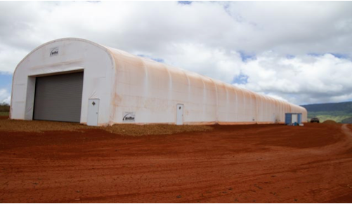
They’ve already built a hangar for the drone, and RCUH’s Ted Ralston, on loan from UH’s Applied Research Lab, told those attending a July 17 workshop on Lanai they want the Hawk30 up by October.
Ralston acknowledged the hangar went up in June without waiting for government exemptions requested in May “realizing permission will have to follow behind.” (Maui County eventually granted RCUH exemptions from both building and electrical requirements in July.)
Why the rush? Because “commercial sponsors have to see progress,” Ralston said.
George Purdy, a 20-year firefighter at Lanai’s airport who takes credit for the island’s selection as a testing ground and putting the HAPS team together, agreed: “Lanai had to show the commercial sponsor capacity.”
The commercial sponsor they’re referring to is HAPS Mobile, a company formed to build the Hawk30 by Japanese tech giant SoftBank and California-based, unmanned aircraft systems manufacturer AeroVironment. Ralston said HAPS Mobile is paying RCUH through a support services contract.
Both insisted the speed with which they’re moving is justified.
“There’s no other place in the U.S. this could work” and moving too slowly, Ralston warned, means Lanai could see “it all go away” to another country like Australia, where Airbus is developing another high-altitude drone, the Zephyr.
One Phase Or Three
Although Ralston insists RCUH only wants a one-time, one-month test flight, he was clearly selling the full scale of HAPS’ operations at the July workshop on Lanai, impacts of which could affect the island for years.
Low-altitude testing is ongoing at NASA’s Armstrong Flight Research Center in California, after which Ralston said the drone ships to Lanai for its high-altitude flight. Forty imported specialists would monitor operations from trailers at an air field already being prepared on former pineapple fields next to the hangar in Lanai’s Palawai Basin.
If the drone gets up and stays up, Phase 2 involves more Lanai flights, using up to five drones, to obtain FAA certification “under rules that don’t yet exist,” Ralston admitted.
“This is like the Wright Brothers,” he said, “it’s never been done before.”
Phase 3 could begin in 2023, when RCUH envisions sending drones assembled on Lanai throughout the equatorial belt, although Ralston conceded Lanai’s selection for commercial operations is up to HAPS Mobile.
Before the July workshop even began 5G was off the table, in response to hundreds of emails Lanai’s Planning Commission received objecting to the potential increase in wireless radiation. Ralston promised 5G won’t come back until Lanai wants it.
“Overhead long-endurance proof of concept and connection to dead spots” are Phase 1’s primary objectives and Ralston said this can be done with 4G.
Those supporting the project, hoping for increased cell coverage, will be disappointed. Ralston said they’d need an FCC license and handoff protocols from cell phone providers, which they don’t have.
Permits And Promises
Because Maui County Code prohibits airport operations on ag lands, many expected RCUH to seek a special use permit which could allow telecommunications on land zoned for agriculture.
The application RCUH filed on June 19 with Maui County’s Planning Department asked for a “use determination” instead, which means it had to make a one-time experimental flight into something about agriculture.
So RCUH proposed planting UH-provided sensors in Lanai’s inaccessible Maunalei Valley, from which the Hawk30 would collect watershed data. This might satisfy communicating with “dead spots” RCUH hopes to achieve, but it wasn’t clear how data collected for a mere 30 days from a remote valley many miles away will contribute to long-term ag use on the ag land it wants to use, and Ralston admitted data-sharing agreements with the landowner haven’t been worked out.
“This is like the Wright Brothers, it’s never been done before.” — Ted Ralston, University of Hawaii
RCUH also suggested the HAPS Project could contribute to STEM education for Lanai students, but not how it would be funded or how lasting an educational program centered on one 30-day flight might be. Lanai High’s STEM teacher David Parman said so far the agreement with RCUH is “a handshake.”
Decision Making
Now that 5G is gone, RCUH will have to revise its application and send it back to the Lāna‘i Planning Commission. RCUH will also have to respond to concerns over radiation, safety, and privacy that surfaced at the July workshop, including whether environmental review under HRS Ch. 343 is triggered.
“If any public funds are involved you should be asking yourselves, why no environmental assessment?” Riki Hokama, Lanai’s County Council representative told the commission.
If RCUH argues environmental review isn’t warranted because only private funds (from HAPS Mobile) are being used on private land (billionaire Larry Ellison owns 98% of Lanai), then Hokama thinks RCUH wasn’t eligible for the government exemptions it got from the county in the first place.
Ralston wouldn’t say how much RCUH’s service contract is worth – UH’s Applied Research Lab has drawn criticism for opaque operations in the past — but it’s worth noting HAPS Mobile has funding of $65 million and NASA will be reimbursed $791,566 for services it’s providing in California.
Planning commissions can impose conditions to permit approvals: perhaps Lanai’s should seek firmer commitments and funding for the promised STEM efforts and explore benefits for the Lanai community for the risks it’s assuming.
After all, Lanaians would have to live under the massive drone for a month — if not more — and it’s no secret AeroVironment’s Helios failed near Kauai in 2003. A second drone, the Global Observer, crashed in 2011.
Getting the Hawk30 into the stratosphere by October just might be a heavy lift.
 GET IN-DEPTH
REPORTING ON HAWAII’S BIGGEST ISSUES
GET IN-DEPTH
REPORTING ON HAWAII’S BIGGEST ISSUES
Community Voices aims to encourage broad discussion on many topics of community interest. It’s kind of a cross between Letters to the Editor and op-eds. This is your space to talk about important issues or interesting people who are making a difference in our world. Column lengths should be no more than 800 words and we need a current photo of the author and a bio. We welcome video commentary and other multimedia formats. Send to news@civilbeat.org. The opinions and information expressed in Community Voices are solely those of the authors and not Civil Beat.