
Hawaiʻi Helicopter Safety: Kauaʻi’s Waimea Canyon To Get Cameras
Weather was the main cause of aviation accidents in Hawaiʻi over the past 20 years. The FAA hopes a network of remote cameras can make the skies safer.
Helicopter pilots flying in one of the most thrilling and potentially hazardous parts of Kauaʻi’s airspace will soon be able to review video and weather data along their flight path before taking off at Līhuʻe Airport.
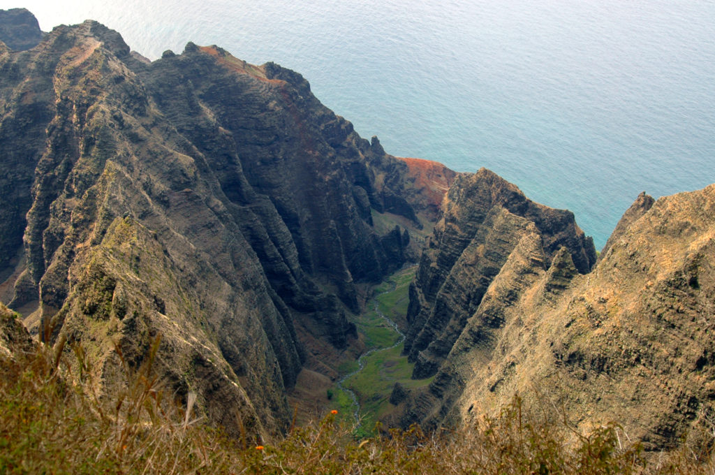
Waimea Canyon, dubbed the “Grand Canyon of the Pacific,” is a highlight for visitors, and a selling point for air tour companies operating on the Garden Island.
But rapidly changing weather over short distances in and around the remote canyon has been linked to several helicopter accidents, including the crash of a Safari Aviation helicopter in 2019 that killed seven people.
Delays in the installation of remote weather cameras in Hawaiʻi by the Federal Aviation Administration contributed to the accident, the final National Transportation Safety Board report released in 2022 found.
The Waimea Canyon cameras, which will be operating by the end of the year, will bring the total across the state to 26, with seven of those on Kauaʻi. There are 300 operating nationwide. The new cameras will partly fulfill the safety recommendations the NTSB issued after the Safari Aviation crash — albeit more than four years later.
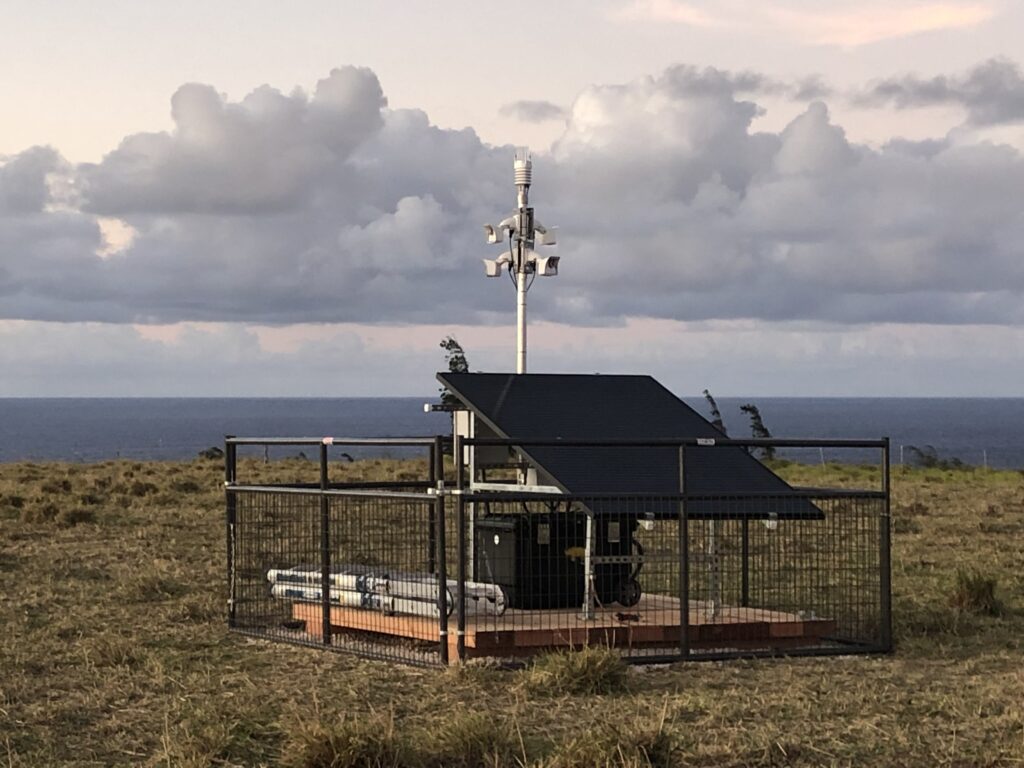
The weather camera units are about the size of a large chest freezer and typically installed on a raised platform with a solar panel and batteries. Multiple cameras are mounted on a pole that can capture a 360-degree view. Weather sensors and video footage on a 10-minute loop stream data online that includes temperature, wind speed and direction.
The cameras are compact enough that they can be installed in otherwise inaccessible locations like mountaintops or in valleys.
Aviation industry veteran Casey Riemer of the Kauaʻi company Jack Harter Helicopters said Monday that the weather cameras planned for the upper and lower Waimea Canyon will be a “game changer” for local pilots but said they are long overdue.
Riemer first encountered the weather camera systems from his flying time in Alaska where a program has been operating since 1999, but it’s taken another two decades for the technology to reach Hawaiʻi.
“I think that the overwhelming majority of those accidents that have happened in Hawaiʻi, involving pilots who continued flying into conditions where they could no longer see where they were going, would have been prevented had those weather cameras been available,” Riemer said.
Fifty-one people have died in 13 helicopter crashes since 2000, including three passengers who died March 26 in a crash landing of an Airborne Aviation helicopter off the Nāpali Coast. The NTSB’s preliminary findings suggest mechanical failure was a factor in that accident.
But weather was the leading cause of aviation accidents in Hawaii between 2003 and 2022, a 2025 study from the American Meteorological Society found.
“Our goal is to get these cameras specifically into areas where there’s no other weather information,” said Cohl Pope, who manages the FAA’s weather camera program out of Anchorage, Alaska.
“So we’re taking an area like Waimea Canyon where the pilots have to fly in blind, they have to fly out, and provide a look at the weather so they can make a decision prior to flying,” he said. “If there is zero visibility, then they’re not even going to take off.”
Riemer, who provided input to the FAA on siting the new cameras, said they would help local pilots determine whether they could even make it around to the west side of the island, a standard route for the nine air tour companies operating there.
“Before we had the weather cameras,” Riemer said, “it was either, get on the coconut wireless and call Auntie or Uncle and get unofficial weather from the west side or the north side, or use publicly available — and not always reliable — weather information from webcams like the one at Hanalei Resort.”
Reimer said in addition to the aviation safety benefits, there are potential cost savings for operators and “not just for tour flights, but for the natural resource management work we do.”
Many of those flights in the Waimea Canyon, Nāpali Coast and Alakaʻi Swamp involve Department of Land and Natural Resources staff working on avian recovery.
“We spend a lot of time up in the 3,000 to 5,000 foot elevation area in the center of the island,” he said, “and we need to know if we can get up there, and do it safely.”
NTSB Criticized FAA Over Delays
The NTSB has regularly expressed frustration with the pace of progress by the Federal Aviation Administration in implementing a list of reforms it says are needed to improve Hawaiʻi’s grim helicopter safety record.
Less than two years ago, the NTSB was calling again for stronger FAA oversight of Hawaiʻi’s air tour industry and improvements to communications infrastructure, including improved aircraft tracking, active flight monitoring by support staff and additional weather cameras.
NTSB Chair Jennifer Homendy wrote then-FAA administrator Michael Whitaker in July 2024 that the agency “remain(s) concerned that there may be a tendency among some companies or individual pilots to develop norms for accepting increasing weather-related risks — until they encounter a situation from which they cannot safely escape.”
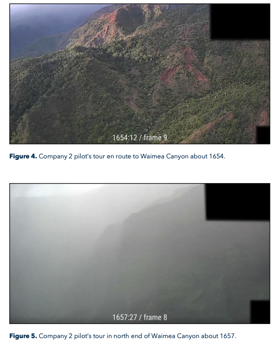
(Provided: National Transportation Safety Board/2022)
That was exactly the scenario in the Safari Aviation crash when the pilot continued to fly through Waimea Canyon in deteriorating visibility without adequate weather information, NTSB investigators found.
“The accident pilot decided to continue his tour into deteriorating weather, eventually losing adequate visual references before the helicopter struck terrain,” they said.
The wreckage of the aircraft was located on a wooded ridge, 3,000 feet above the Waimea Canyon floor, and 1/2 mile from its designated route.
Video footage captured by a pilot from another helicopter showed visibility in the Waimea Canyon at the time of the accident changing from clear to impenetrable in the space of only three minutes.
The limits of air safety infrastructure, including a lack of ground-based weather stations, and radio communication blackspots like those of the Nāpali Coast, have led to air tour pilots “having to rely on their own in-flight visual weather assessments,” the NTSB said.
Limited Alaska Data Points To Improved Safety
The installation of a weather camera network across all Hawaiian islands since March 2021 is part of an attempt to create a better safety culture in the state’s lucrative commercial air tour industry.
Pope says there was an 89% drop in weather-related aviation accidents in Alaska over a seven-year period, following the introduction of the weather cameras there. And there was a 50% drop in aviation fatalities between 2000 and 2009 after the implementation of a range of safety projects in Alaska that included weather cameras, according to the Centers for Disease Control and Prevention and the National Institute for Occupational Safety and Health.
But competing funding priorities within the FAA have been a major factor in the pace of the rollout, Pope said. There was $163,000 for the weather camera program in Hawaiʻi in the FAA’s Air Traffic Organization budget for the 2025 fiscal year.
That funding is meant to support ongoing maintenance and also help update the units with newer camera technology. FAA spokesman Christopher Mullooly said there was no set cost per camera because the requirements for installation, including power and data transmission needs, can vary widely.

Pope said that the units they are installing in Hawaii are on a 6-foot by 6-foot platform that houses the cameras and electronics and is run by two solar panels, eliminating the need for additional power. The camera uses cellular towers to transmit. Once installed, the camera units have proven themselves to be pretty hardy, he said.
“We have cameras out there that have been in the field in Alaska for five years and never needed any type of maintenance, maybe cleaning the lens occasionally or something like that.”
But power outages or other factors can take the cameras offline for periods of time. And in Alaska and Hawaiʻi, the FAA has run into difficulties obtaining land leases to place the cameras on private property, he said. It’s unclear how much this issue would impede additional camera installations in the future.
Pope said that the weather camera at Līhuʻe Airport, the main base for Kauaʻi’s air tour industry, was currently offline. The unit has to be moved because of an issue with the FAA’s lease.
It’s still too soon to determine the impact of the technology in Hawaiʻi, but Pope said pilots and operators like Riemer had been heavily involved in helping expand the camera network.
The weather cameras have their limitations, including the time-restricted video footage, and they are not as effective in detecting sudden changes in wind conditions, Riemer said.
High winds in Waimea Canyon contributed to the mid-air breakup of a Robinson R44 helicopter in July 2024. Three people died when the helicopter came down in 80 feet of water off the Nāpali Coast.
Nevertheless, Riemer said that he had one other Kauaʻi location on his wishlist for a permanent weather camera: Nu’alolo Ridge.
“If you look on a map it’s the point that sticks out the furthest,” he said, “and a camera there would give views of the Nāpali coastline in both directions.”
Air tour operators Island Helicopters on Kauaʻi and Rainbow Helicopters on Oʻahu were asked to comment on their use of the weather camera network but did not reply to emails.
A spokesman for the National Transportation Safety Board declined to comment on the progress of the weather camera program in Hawaiʻi.
Civil Beat’s reporting on Kauaʻi is supported in part by a grant from the G. N. Wilcox Trust.
