
Hurricane Ignacio Slowly Moving Toward Hawaii
The storm could reach the Big Island by Monday.
Hurricane Ignacio is continuing to move northwest toward Hawaii, potentially reaching the Big Island on Monday morning and then crossing over the rest of the islands, according to the National Weather Service’s forecast Friday.
Maximum sustained winds were near 90 mph and the storm was moving 8 mph.
A flash flood watch is in effect for Oahu, Maui, Lanai, Molokai, Kauai and Niihau.
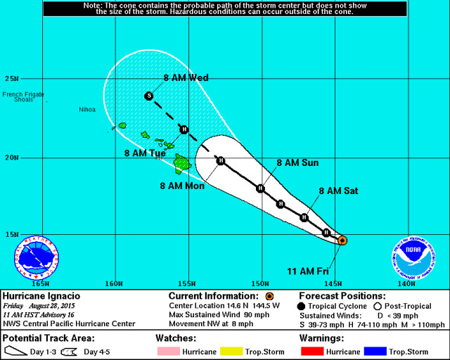
Hurricane Ignacio was tracking toward Hawaii, according to Friday’s forecast.
National Weather Service
“We understand the public is fatigued from experiencing four major approaching storms so far this season, but we urge people to take the weekend to prepare their homes and families for impacts that could be felt statewide,” said Doug Mayne, state administrator of emergency management, in a release Friday.
“Severe weather associated with Ignacio is expected, and with Jimena not far behind, we need to ready ourselves and our loved ones as much as possible with the time we have. We will continue to work with our county, state and federal partners and leadership to monitor the storms and provide the public with timely updates as we receive them.”
Ignacio may strengthen more through Saturday, according to the forecast. It was a Category 1 hurricane 840 miles east-southeast of Hilo at 8:30 a.m. Friday.
East- and southeast-facing shores of Hawaii Island and Maui can expect advisory-level surf Saturday and warning-level increases Sunday through Monday, the release said. Tropical storm force winds could begin to impact Hawaii Island as early as Sunday evening.
The public is urged to be cautious and continue to follow the storm’s progress, as its direction may shift.
Gov. David Ige and the county mayors have been involved with daily NWS briefings via video teleconferences involving the Hawaii Emergency Management Agency, local emergency management and civil defense agencies, and federal and state partners, the release said. They will continue to participate through the weekend as the storms continue their approach.
If Ignacio tracks across all islands, impacts could include hurricane-force winds, storm surge and widespread flash flooding, the release said. If the system tracks to the north or south of the state, there is potential for extremely gusty winds, heavy rain and thunderstorms.
The NWS is also closely monitoring Jimena, which remains a potential threat to the islands, the release said. It is currently a Category 3 hurricane, and will rapidly strengthen to reach Category 4 status Saturday. Forecasts show the system weakening slightly and crossing into the central Pacific on Tuesday night as a Category 3 hurricane.
To learn more about how to prepare for a hurricane, visit here.
