

King Tides And Sea Level Rise Eating Away At Pearl Harbor Bike Path
Riders on the popular trail can run into flooding, forcing them to detour to more hazardous roadways.
Sections of the Pearl Harbor Bike Path are often impassable because of flooding, but it will be at least 2028 before there’s even a plan to tackle the issue.
University of Hawaiʻi data and photographs going back a decade show there are at least eight spots along the 5-mile path from Waipahu to the Aloha Stadium where significant flooding occurs. And in low-lying areas along East Loch and ʻAiea Bay the impact of inundation on the trail can be dramatic, based on a recent video submitted by a Civil Beat reader.
The footage was captured on Feb. 19 by Aaron Yri as he cycled east across a bridge from the Neil S. Blaisdell Park over the Waimalu Stream.
The camera shows the bike path sloping down to Hekaha Street behind a car dealership on Kamehameha Highway. Yri stops at the edge of a large muddy pool, where drivers navigate through the water that is clearly impassable even for cars, not to mention bikes.
Yri has been using the bike path more frequently this year to commute to work in the mornings.
“I ride about 10 miles from Ewa Beach to the stadium rail station where I transfer to a bus to get to work,” he said. “And at night, I avoid the path and just use the rail to get back to East Kapolei to ride back home on safer routes.”
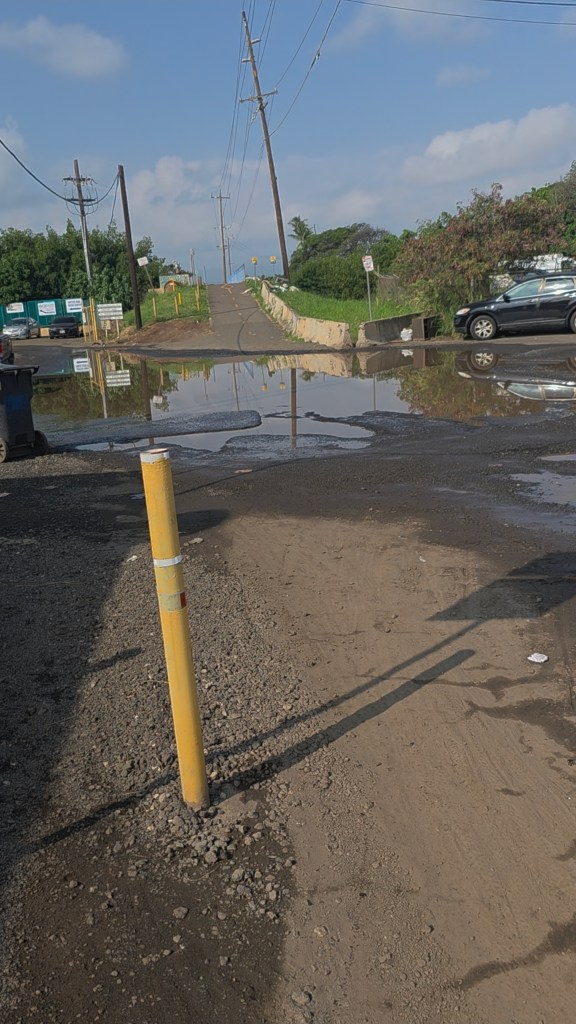
When the path floods, he has to make a detour, which takes him to the narrow sidewalk on Kamehameha Highway. It’s a lot less protected and a lot scarier.
“I don’t feel it’s safe enough to ride a bicycle on this road, as there is no dedicated bike lane with speeding vehicles passing by,” he said.
The Honolulu Department of Transportation Services agrees, designating that section of highway a heavy traffic zone that is not “bicycle-friendly” on its own bike maps.
Yri said he reported the issue using both the previous version of the city’s HNL 311 app, and the newly relaunched platform, but didn’t receive any response.
Honolulu DTS staff are aware of the issue at the location shown in the video, and will evaluate it as part of a plan for the South Shore Trail that will eventually link Nānākuli to the UH Mānoa campus, spokesperson Travis Ota said in an email Monday.
The transportation department hasn’t determined if the location pinpointed by Yri is just a spot that floods during rainfall or if his video was taken during a tidal event, Ota said. Maps show Hekaha Street is only 7 feet above sea level at the point shown in the video.
The department will study both scenarios, Ota said, and also is “exploring potential design concepts to address impacts from sea level rise and king tides in this area.”
King tide events usually occur May through July, according to UH Hawaiʻi and the Pacific Islands King Tides Project, which has been active since 2015. The project uses submitted photos to track incidents linked to sea-level rise and other coastal hazards.
But a fix for that part of the bikeway isn’t likely anytime soon because even the planning phase for the South Shore trail won’t be complete until 2028, and the project itself could take up to 20 years overall, DTS deputy director Jon Nouchi said in December 2023.
For Yri, that’s a bummer: “It’s a shame the city doesn’t put a higher priority on the bike path,” he said.
Some renovations have begun on other sections of the Pearl Harbor Bike Path though, with another section in ʻAiea reopening last October.
Who Can Be Contacted?
Roger Morton, director of Honolulu Department of Transportation Services, 808-768-8303.
Residents can also submit reports online at honoluluhi.citysourced.com; by email at complaints@honolulu.gov; by phone at 808-768-4381; or through the free Honolulu 311 app.

Got A Tip For Fix It!?
Please tell us where the problem is, as specifically as possible. A cellphone photo would be helpful. Here are ways to get in touch:
You can submit in minutes using this form.
You can send us an email at news@civilbeat.org. Put “Fix It” in the subject line so it doesn’t get lost.
You can send a letter to the newsroom at PO Box 10857, Honolulu, HI 96816.
We won’t use your name without your permission but, if we pursue your fix, we will get back to you with what we find.

