See: Oʻahu Evacuation Map, Zones, Shelters Amid Wahiawā Dam Threat
Get the latest on flooding concerns, power outages and more as a Kona low storm bears down on Hawaiʻi.
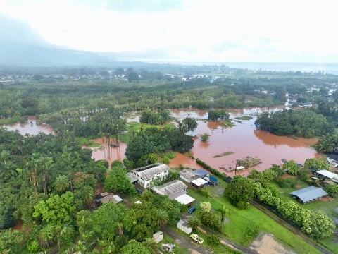
Oʻahu was under a flood advisory after heavy rains from a passing storm caused damage particularly on the North Shore, where people reported homes were wrecked, waters reached chest high and cars were overturned and flooding made some roads unpassable.
Rains were expected to continue Sunday as well, according to the National Weather Service.
Evacuation Zone Map
Honolulu emergency officials rescinded evacuation orders Saturday. Previously, the evacuation zone stretched from Kaʻena Point to Papaiola Beach and extended into Waialua and Haleʻiwa.
Can’t see the live embedded map below? View Honolulu’s evacuation zone map here.
Oʻahu Evacuation Shelters
Just one shelter remained open at Kāneʻohe District Park (45-660 Keaahala Rd) as of Saturday evening, according to the Oʻahu Department of Emergency Management:
| View Shelter Map |
Get the latest news on how the Kona low storm affects Oʻahu and more:
Oʻahu Power Outages
Nearly 9,000 Hawaiian Electric Co. customers were in the dark as of 10:40 a.m. Friday as heavy rains pounded the island, but that number had dropped throughout the day.
Most of those affected lived on the northern half of the island as far mauka as Wahiawā and stretching from Kaʻena Point to Kawela Bay on the North Shore, though thousands were affected in East Honolulu from Hawaiʻi Kai to Waimānalo.
| View Live Outage Map |
Oʻahu Emergency Alert Signup
HNL Alert is the official City and County of Honolulu emergency notification system. View the latest emergency alerts from local officials.
Concerns that are not pressing emergencies can be directed to the city at 808-723-8960, Mayor Rick Blangiardi said during a Friday morning news conference.
| Sign Up for HNL Alert |
Storm Forecast
Oʻahu’s flash flood warning was downgraded Saturday to a flood watch, according to the National Weather Service.
While Oʻahu was hit hardest Friday, officials warned heavy rains would keep up on the island through the weekend and appeared headed for Maui County, too, into Friday night.
Weather was expected to improve on Monday, from west to east.
| Latest Oʻahu Forecast |
What is a Kona low storm?
Kona lows are subtropical cyclones that tend to form in the winter, according to the National Oceanic and Atmospheric Administration.
Kona means “leeward” in the Hawaiian language. These storms buck the usual trends for Hawaiʻi by moving from south to southwest instead of coming from the east or northeast. Because the leeward sides of the islands tend to be drier and see less rainfall, they are especially susceptible to floods, landslides and mudslides, according to NOAA.